We left Playa Aserradores heading for Leon, the on-again off-again capital of Nicaragua since the country’s independence in the early 19th century. At first, liberal regimes favored Leon as a center of government while more conservative ones preferred its colonial sister city of Granada, and as seems to be all too common in Central America, US interests often played a role. Managua was made the capital as a compromise.
In the 50 years after independence, US companies developed significant influence in the fledgling nation, including an international proposal to build the first shipping canal through Lago de Nicaragua to the Pacific and Caribbean. They eventually opted to build it in Panama but since then have ensured that any government that came to power was pro-American. Interestingly, there are new plans in the works for a new, larger canal in Nicaragua to accommodate some modern ships that won’t fit through the Panama Canal.
When General Jose Zelaya seized power in 1893, the US incited a civil uprising culminating with 400 Marines landing in Nicaragua and permanent bases being established. When Augusto Sandino led a guerilla campaign to protest the military presence, a US-controlled National Guard assassinated him and installed a favorable dictatorship. But Leon lived up to its revolutionary reputation when the dictator, General Anastasio Somoza, was killed there after a 20 year rule; The “Frente Sandonista Liberacion Nacional” was formed soon after and would fight for 20 more years under Somoza’s sons before taking over the government in the 1980’s. Under Ronald Reagan, the US funded the “Contras” fighting against the liberal “Sandinistas.” When this type of support became politically unpopular, a scheme was devised to sell arms to Iran and funnel the money to the Contras. I was 8 at the time, but it seems that even the people involved have a hard time recalling what happened, at least under oath.
Wait, so we sold arms to Iran? But they’re the ones we’re super scared about now, right? Oh, it was so they could fight and defeat the Russians in Afghanistan. Wait, those guys are the Taliban now? But we HATE them, right? And now we’re fighting them in Afghanistan, and we like the Russians again? Okay, why did we invade Iraq? because a bunch of Saudi’s attacked us, but we like them too much to be mad at them? Oh US, why do you remind me so much of a bitchy high school girl?
When we drove through Leon, the only thing they seemed to be rebelling against was taking a power washer to their beautiful colonial churches. We felt a little like we had when we first entered Oaxaca; Where’s the pretty stuff? Only Oaxaca delivered, and Leon never quite did. We took a few laps around the central square, everyone honking and driving like mad men – and that’s coming from someone who’s been driving down here for almost 4 months – and decided it wasn’t for us. We snapped a couple pictures as we looked for the best way out of town.


The “best way" turned out to be 40 miles of pretty much the roughest road we’ve encountered on the trip. It was hard to imagine that the road we were on was the one marked in thick yellow lines on the map, but the GPS confirmed we were on the right road. We bumped along, swerving to one side or the other in search of the smoothest surface. It’s possible the upper road, closer to Lago de Managua, though smaller and more out of the way on the map, is better though we’ve been unable to find anyone who’s driven it.


As we approached Managua, we saw a crew of three guys in a pickup truck filling potholes. Talk about job security.
For some reason, our street level maps wouldn’t load in the GPS, and we entered Managua appreciating what Chad and Emily go through on a daily basis. We were admittedly frustrated and maybe just a little jittery about being on our own again. We passed four roundabouts, and at each, gas station attendants told us to go two more roundabouts. That kind of thing can make you feel al little “exposed.” After following the guy in front of us up onto the sidewalk and across a stretch of grass to avoid a stall in our lane, we finally saw a sign for Mayasa and knew we were heading in the right direction. Not a sign for Granada, the most frequently visited city in Nicaragua on the main route between it and the capital city, mind you but for Mayasa.
Granada was a lot like Antigua, only not as much. Colonial architecture based on a grid around a central square filled with families and tourists; That part was the same. But the façade crumbled within a block in any direction from the square where streets became clogged with honking traffic and throngs of people or worse, turned dingy and empty with a few sketchy looking characters occupying the corners. The only exception was a wide, cobbled pedestrian promenade lined with outdoor cafes. There you found the gringos, particularly Americans after a notable absence through the rest of Central Americas, but with them came relentless solicitations from street vendors and a few beggars.


We found ourselves a little negative at this point. As beautiful as parts of it were, we’d seen this city before. We’d sat in outdoor cafes at sunset and waited too long for waiters to bring us our check. We were saturated with culture and had no interest in the local crafts. Were we burnt out? Spoiled by what we’d seen? Just missed traveling with our new friends?


Even the “Towners” that looked like miniature versions of the Sprinter we’d gotten so used to seeing in our rear view mirror made Ann sad. I just kept hoping to see Kiki. Note to self: Do next trip in a Towner, get a black miniature Chow, and host blog at http://sprinterLITE.com.
When we were thinking we’d go all the way to Tierra del Fuego, the next step always seemed clear; Drive South. From blogs and guidebooks, we knew about all the great things to do along the way through Central America and feel like we’ve put together our own trip hitting a lot of those highlights. But an interesting thing happens about now on a lot of these Pan American Highway trips; Possibly because people are feeling the same way as we are now and possibly because the prices of accommodations, food and everything else begins to rise precipitously after Nicaragua, but the pace speeds up. Maybe it’s because they start looking at maps of South America and realize Panama’s only a few days’ drive or they’re just ready for something new.
But we’re in a different position; We’re approaching the end of our trip and entering some of the countries we’d been most excited to visit. And we have time to really enjoy them; We found a room - actually more like an apartment that would be great if while reading this you’re thinking “Man, Granada sounds great! I’d like to spend a few weeks there!” – and spent the next morning pouring over our outdated Costa Rica guidebooks, querying friends on Facebook, searching online and making a plan to do just that.
In the afternoon, we took a cab down to the shore of Lago de Nicaragua, about 1 km away. It was Saturday morning, but the waterfront, dotted with occasional restaurants, was completely empty. At a parking lot at the end of the road, we were mobbed by touts offering rides on the lake in one of the 50 empty boats tied up in a lagoon. Uninterested and still unable to tell if the sketchy vibe we were getting was real or some lingering paranoia, we waited 20 minutes until the next cab dropped off a load of confused gringos and snaked it back to town before they could realize their mistake. An interesting note: Cab drivers will just keep picking people up as they go until their car is full, a lot like a colectivo. Something I don’t think we’ve seen anywhere else.
We had another drink on the promenade and a nice dinner in a parking lot converted to a ranch-themed restaurant with hay bale walls, a mural and a stuffed raccoon. Walking back to the apartment, it was fun to look into each set of double doors as we passed. Inside many of the high walls that line the sidewalks were huge courtyards with pristine gardens that had been homes of the wealthy elite. Since many have been converted to multi-family units, you never knew if inside would be a mansion, a boutique hotel or a family sitting in wicker rocking chairs in front of a flickering TV.


Our research the day before had revealed that in our hurry to escape Managua, we’d sped by a couple natural areas that were exactly the kind of thing we were looking for. We backtracked a half an hour towards Volcan Masaya, yet another of the products of the volcanic arc created by the subduction of the Cocos plate under the Caribbean.


Evidence of recent eruptions as well as Volcan Concepcion on Ometepe Island in Lago de Nicaragua as we looked south down the line of volcanoes.


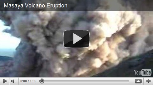
And the coolest thing about Volcan Masaya is that you can drive right up to the crater. Our throats and eyes started burning from the sulfur fumes as soon as we got out of the car in the most recent of many “You know, they really should not let people do this” moments we’ve had on this trip.


We climbed the stairs to a viewpoint where we could look farther down into the crater.


It was about then that we remembered the signs in the parking area advising people to park facing the exit. Check out the video taken from this viewpoint in 2008 to see why…

Now heading back towards Granada, a side road took us up to our destination for the night, Laguna de Apoyo. We’d weeded through the fickle whiners and effusive sycophants on TripAdvisor to determine that “The Monkey Hut” might be more hostel than we wanted and “Norome” might be too fancy. The middle ground was San Simian, 5 or 6 cabanas perched on a hillside overlooking the lake at the end of a rough kilometer or so of dirt road. We were greeted by an American woman who was “hotel-sitting” for friends and led to their one available cabana, the one closest to the water. Two chairs and a hammock overlooked the stunning lake just steps from the bar. Once inside the simple room with a queen size bed, a twin and a fan, a door led back outside to an open air bathroom. Ann couldn’t wait to take a shower out there, and I couldn’t wait to see what jumped out of this toilet.


We walked down to the small private dock for a swim in the notoriously mineral rich, thermal waters. Digging our toes into the sand under the water, we could feel the volcanic heat coming up from below like the warm dirt on the top of Volcan Pacaya in Guatemala. Pretty amazing.


Afterwards, I spent the afternoon writing while Ann played with a friendly local dog. We were feeling much better now; We had the beginnings of a plan for Costa Rica and would be crossing the border the next morning.


